Roopkund
The Mystery Lake
Roopkund
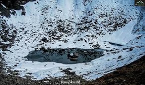
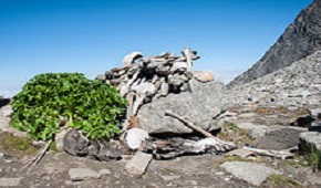
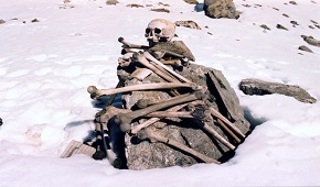
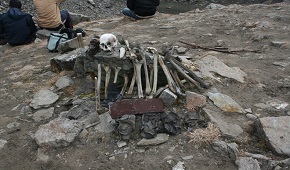
Roopkund (locally known as Mystery Lake) is a high altitude glacial lake in the Uttarakhand state of India. It lies in the lap of Trishul massif and is famous for the hundreds of human skeletons found at the edge of the lake. The area is uninhabited, located in the Himalayas at an altitude of 5,029 metres (16,499 feet).Surrounded by rock-strewn glaciers and snow-clad mountains, the lake is a popular trekking destination.
A shallow lake, having a depth of about two metres, Roopkund has attracted attention because of the human skeletal remains that are visible at its bottom when the snow melts. Many theories and opinions exist, from purely spiritual to scientific ones, attempting to explain the existence of these skeletons, which date back to 9th century CE. Because of the human remains, the lake has been called Skeleton Lake in recent times.
Roopkund Trek
Brief Itinerary
Region :- Uttarakhand
Duration :- 08 Days
Grade :- Moderate to Difficult
Max Altitude :- 15,696 Ft.
Approx Trekking Km :- 53 kms.
Day 1: Lohajung to Ghaeroli Patal via Wan
Day 2: Ghaeroli Patal to Bedni Bugyal
Day 3: Bedni Bugyal to Patal Nachauni
Day 4: Patar Nachauni to Bhagwabhasa
Day 5: Bhagwabasa to Roopkund. Further up to Junargali. Return to Patar Nachauni via Bhagwabasa
Day 6: Patar Nachauni to Lohajung via Bedni and Wan
Detailed Itinerary
Day 1: Lohajung to Ghaeroli Patal
(5 - 5½ hrs. Level: Combination of a short descend and a steep ascend)
Start the day with an hour’s drive to Wan. The initial trail is cemented and through a cluster of houses. It's half
an hour's ascent and then a short descent to the gurgling Neel Ganga.
The bridge on Neel Ganga is an idyllic location to take a breather. Trees overhang the river and the water trips and falls over boulders
in the shade. The water here is cool and refreshing.
From here begins the beautiful ascent to the first camp site, Geroli Patal.
The trail now winds through Oak and Rhododendron forests and the path is strewn with dry leaves that crunch and crackle beneath your trekking shoes.
This is a trek of about an hour and halfa that brings you to a clearing with a green trekker's hut. This is Ghaeroli Patal.
Day 2: Ghaeroli Patal to Bedni Bugyal
(2 - 3 hrs. Level moderate: Stiff climb that opens up to a slight ascend in the meadow)
The trail begins to climb steeply into the Oak and Rhododendron forest. And after half an hour of ascneding stoned steps the
trail opens up to a huge meadow. Take the trail to right that will take you to Ali Bugyal.
All tiredness forgotten, soak in the mesmerising sight of the undulating meadows of Ali Bugyal. You are on the top of a ridge that spreads in
every direction -- acres and acres of green meadow scooped out of the mountainside.
Clouds drift in from below, glide over the ridge and slide down the either side, all in a slow swift motion. You watch countless horses grazing
on the bounty of nature. Foals tear themselves across the turf in an uninhibited abandon.
The worst of the climb is behind you. Leisurely walk your way to Bedni Bugyal, 5 kms away and a mildly descending trail initially. If you are
tempted to take off your shoes and allow the feel of the carpet on your toes, just go ahead and do it!
Towards the end of Ali Bugyal there's a short switchback climb of 20 minutes before the trail levels out to a gentle trail to Bedni Bugyal. It
takes about an hour to get to Bedni Bugyal from this point.
Day 3: Bedni Bugyal to Patal Nachauni
(2½ - 3 hrs. Easy assent at the beginning followed by gradual decent)
This is a light day and it helps you acclimatize before hitting the higher camp. If you reach Patal Nachauni early,
you may even think of an acclimatization trek to Kalu Vinayak and return by sun down.
The trail to Patal Nachauni or Ghora Lotani climbs out of the Bedni campsite in a gradual, easy meander. From your Bedni campsite you
can follow it with your eye for 3 kms before it disappears into a saddle in the mountain.When you cross the saddle, the trek exposes you
to the other side of the ridge. The scenery is differently mesmerising. For the first time you also see remnants of the winter snow on
the mountain flanks (on the other side). It is still meadow country and below you are the meadows of Ghora Lotani, the last stop for the
horses. Beyond Ghora Lotani the meadows merge into the mountain side.
There are two ways to catch the trail to Ghora Lotani and Bhagwabhasa beyond. The easier option is to retrace your steps of yesterday
to the point where you left the main trail to get into the Bedni campsite enclave (5-7 mins walk backwards). Get on the Roopkund trail
and carry on your hike up and above the Bedni Camp site. Another option is to start from your camp site, skirt the Bedni Kund from the
right, climb up the slope behind the Kund, and climb further up to the trail from any direction you deem fit. This will save you half
an hour to 45 mins of trekking time, but can leave you breathless.
Roopkund trek Bedni Bugyal to Bhagwabasa: In the picture below, the route marked in yellow is the regular trail. The one in green are
the short cuts that you can take. Let the picture not fool you. It is quite a climb to reach the 'yellow' trail. Click on the picture
for a bigger view.
Ghora Lotani makes an excellent camp site. In fact an additional day spent at Ghora Lotani will help to acclimatise to the altitude,
plus offer you great views. Not much has been written on Ghora Lotani but think of camping here either on your way to Roopkund or on
your way back. It offers as good views as Bedni and has the added bonus of a strange sense of isolation. You can just about camp
anywhere at Ghora Lotani, but ideally look to camp near the end of the meadows. A clear stream spews out of the side of slope and
makes for a very good water source.
Choose to camp at the Ghora Lotani meadows or a head up a bit to the saddle and stay in the eco shelters. The view here is beautiful
though a bit exposed to the winds. Here, on your left you can see a trail that heads down to Bhuna (and further on to Sitel and
Suthol). Upwards is your climb to Kalu Vinayak. The saddle signals the end of the meadows.
The Ghora Lotani camp site: Remarkable in its isolation. 12,500 ft.
Patar Nachauni: The legends are more impressive than the location. Take shelter for the night at the eco huts built.
Day 4: Patar Nachauni to Bhagwabhasa
(2½ -3 hrs. Steep ascent followed by level walk. Level: Descending initially, moderate climb at the end)
You start at the meadows and make a steep dash to gain height and finally camp on the snow line. The day’s trek
will also see you climbing from 12,500 ft to 14,500 ft. For the first time on the trek you will feel the effects of altitude and
thin air.
Start your day early again. You want to be in Bhagwabasa as early as possible to acclimatise yourself to the altitude before your
final push to Roopkund.
The climb to Kalu Vinayak is a steep zig-zag up the mountain side and will take you to 14,500 ft. The distance isn't much, and
the zig-zag trails makes you gain height very rapidly. Climb this section very slowly.
There really is no hurry and even if you are the slowest on the team you can reach Bhagwabasa in comfortable time. Take 10 minute
breaks every 15 minutes. This is a cruicial height where most climbers feel the thinness in the air. You get breathless very soon
and sometimes even feel dizzy. This would be ok, if you did not have to do the Roopkund climb the next day. Most folks climb this
section like any other climb and find it difficult to acclimatise to the Roopkund altitude later on. Treat this section as the
most crucial bit of your trek. In climbing time it takes around 1½ hrs to climb to Kalu Vinayak. Stretch it to 2½ hrs, even if
you can climb quicker. By doing this, you'll find your body adjusting to the increased height and the lack of oxygen.
Climbing to Kalu Vinayak is a thrill and everytime you look up and take a bend on the trail, the ridge line gets closer, drawing
you, inspiring you. Around you are the green, sheer mountainside. Below, you can follow the trail that you took from the first
saddle over Ghora Lotani and finally to Kalu Vinayak.
Half way up to Kalu Vinayak, looking down over Ghora Lotani. You can follow the trail all the way from the first saddle to up
where I am. From this height everything looks tiny.
Kalu Vinayak gets its name from the black Ganesh idol enclosed in a stone shrine just as you finish the climb from Ghora Lotani.
Lots of temple bells and a large plate for you to make a donation. Everyone offers a prayer here for a safe pilgrimage to Roopkund.
A donation of Rs 10/- is standard. Some offer biscuits instead! Choose!
The Kalu Vinayak Shrine: You touch snowline here.
Beside the Kalu Vinayak shrine and right next to it you hit your first patch of snow. You are at the snow line.
The trail from Kalu Vinayak to Bhagwabasa is easy and gently sloping downwards. Bhagwabasa is 2 kms away and you can see the
Bhagwabasa huts if you follow the trail with your eye. The trail meanders through snow patches.
Be careful on these snow patches. In June, by mid-day, they get soft and you can find yourself sinking to your knees in them.
Step gingerly, quickly and skip your way across them. Better still, skirt around them.
Bhagwabasa is a cluster of stone huts put up by enterprising locals. The charge is on a bed basis. It could be Rs 150 to Rs 200
per bed depending on the season. On lean seasons the rates could go down to Rs 50. If you are staying at Bhagwabasa the locals
will also cook for you at an additional cost. Carry your own sleeping bag -- the nights are extremely cold.
If you are carrying tents, then don't pitch camp at Bhagwabasa. Move ahead for another 5 minutes and you get a camp site on your
left. This is Hunia Thal, a small clearing. There's space enough for 4 tents and no more. The place is rocky, but you don't have
much of an option. If the sky is clear and the team is fit, its a good idea to attempt Roopkund in the afternoon. The next day
serves as an additional buffer.
The Hunia Thal campsite: Just room enough for 4 tents. Note the rocky terrain. 14,500ft.
At Bhagwabasa, night's turn extremely cold. Inside tent temperatures dip to 1°C. Outside I measured at -2°C at 2.30 in the night.
These are mid summer temperatures. In September-October temperature will dip further to -5°C or -6°C. Bhagwabasa is windy too.
In the wind chill the -2°C feels like -6°C. You need to put on all your warm clothings and then get inside your sleeping bag to
brave the night.
Day 5: Bhagwabasa to Roopkund. Further up to Junargali. Return to Patar Nachauni via Bhagwabasa
(2½ - 3 hrs to Roopkund. 2½ hrs return to Bhagwabasa. 3½ hrs return to Patal Nachauni. Level: Moderate-Difficult.)
You need to start your push to Roopkund at 5.00 am. The sooner the better. You need to climb up to Roopkund
while the snow is still hard. In the mid morning the snow becomes soft and your feet start sinking in. You want to avoid this.
There's plenty of snow even in the middle of summer.
From Bhagwabasa it is a 5 kms gradually ascending walk to Roopkund. Towards the end the trail climbs sharply through a series of
switchbacks and a steep climb over a snowy flank to reach Roopkund. The stretch isn't long, but the entire stretch is on snow patches.
At some parts the slope is steep but most parts are easily trekkable. Those trekking alone need to carry ice-axes to cut steps on the snow.
The climb to Roopkund: Expect good amount of snow during most parts of the year.
It takes about 2½ hrs to climb up to Roopkund. Ideally, if you have started at 5.00 am then you are going to get to Roopkund by 7.30
or 8.00 am. The climb is deliriously exhilarating. The last stretch of climbing over the snowy flank on the left requires support of
all four limbs, but is over in 10 mins. Roopkund is right over the edge, two minutes away and yet you can't see it unless you get there.
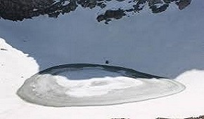
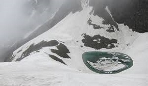
Roopkund is a crater on the mountain face, a dip at the cusp of the mountain. It is much bigger than what most internet pictures suggest.
All around are snowy flanks of the mountain. You have to actually climb down 50 ft to reach the edge of the lake.
On the internet, Roopkund is reported at 16,500 ft. However, GPS readings suggest that Roopkund is not more than 15,500 feet. Whatever the
altitude, you will feel the thinness of the air. Climbing a few steps takes your breath away.
Getting to Roopkund is meaningless if you don't climb up to Junargali. All trekkers must attempt Junargali unless the weather does not permit it.
From Roopkund, the sharp ridge line that towers above you is Junargali. It doesn't take much time to get to Junargali. The route is over snow
that gently inclines upwards until it reaches the face of the mountain. After which it is a steep clamber on the mountain face to reach Junargali.
The climb isn't for long; perhaps 200 ft. It gets over in perhaps 15-20 minutes. Care must be taken while you are climbing to Junargali. A slip
can result in a bad fall. A rope with you is very handy.
An unusual angle of the Roopkund lake rarely seen in photographs. On the far left is the trail leading up.
Returning from Junargali: Start your return by 9.30 am from Junargali, timing yourself such that you are back at Roopkund by 10.00 am and after a
brief rest, you are on your way down.
Trekkers often find getting down from Roopkund difficult. The snowy slope looks tricky and dangerously sloping. You may need to squat on all
fours to negotiate the immediate flank of snow as you get off Roopkund. This is the difficult part but the lower you get, it gets easier
progressively. Once out of the switchback descent, it is a easy walk back to Bhagwabasa. However, step carefully on the snow patches. By mid
morning they are soft and slippery. Always trek down in small groups.
You should reach Bhagwabasa within 2½ hours.
It makes no sense to camp on your return at Bhagwabasa. Move down to Ghora Lotnai. It is a long, exhausting day of trekking, but the benefits
are many. You get the advantage of spending the night at a lower altitude and a warmer location. In addition you are closer to Wan and can
plan your exit out of the trek easily. Make yourself a light lunch and head back to Ghora Lotani. It is a 2 hr descent.
Day 6: Patar Nachauni to Lohajung via Bedni and Wan
(6½ hrs to Wan. 1 hr drive back to Lohajung. Level easy-moderate)
There is a sense of elation as you return through Bedni. And the oak forest over Wan is just the icing on the cake
that you want. Retrace your path to Bedni Bugyal. Pass the Bedni camp site and take the trail heading to the right and below.
20 minutes later, you get to the tree line and sharp descent that signals the end of the meadows. Watch for the descending trail
on your right. The main trail moves ahead to Ali Bugyal.
Trishul on the way to Wan: A rare shot of the Trishul on a clear day on the way down from Bedni Bugyal to Wan.
Run down into the oak and Rhododendron forest. Half an hour into your decent, you get to a clearing. The green trekker's huts signals
Ghairoli Patal. On a clear day, you get astounding views of Mt Trishul commandeering over the area. Rest here and if your team is
not in a hurry, step into the flat oak forest on your right. The setting is straight out of a movie set with beams of light streaming
in from above and a crunchy cover of brown leaves below. Spend sometime here at the wonder of nature and rejoin the trail.
It is a steep ridge descent to the Neel Ganga. Quicker trekkers reach the river in one and a half hours. The slower ones take two.
Take your time because you will rarely see a more wondrous stretch of forest cover.
The bridge on the Neel Ganga is an idyllic location to wash the dirt and grime of the week long trek. Trees overhang the river and
the water trips and falls over boulders in the shade. The water is cool and refreshing.
From the river it is a short half hour climb to the ridge above Wan village. After spending days in the wilderness, you finally come
to a busy civilization. Some welcome it and some hate it. There are many routes to the bottom of the Wan village, and all roads
eventually lead down to the road junction (Kasar Bagad) near the hydel project. It takes about an hour and half to get down to Kasar
bagad. It is a steep descent.
There is an alternative longer route to get down to Wan. From the ridge top of Wan, take the main trail that runs to the right.
Follow the trail until it reaches the Cyprus trees at the lower Wan village. Spend time looking at the Cyprus trees because they
are centuries old. A short descent later you touch the road. You can ask your vehicle to meet you at this junction.
From Kasar Bagad regular vehicles ply to Lohajung and you get a welcome cup of tea at Hari Singh Bugyali's shop. By Jeep it is an
hours drive to Lohajung over a road that bumps and rattles all the way. The thrill of the ride stays for many days to come.
Roopkund (locally known as Mystery Lake) is a high altitude glacial lake
in the Uttarakhand state of India. It lies in the lap of Trishul massif
and is famous for the hundreds of human skeletons found at the edge of the lake.
View Details
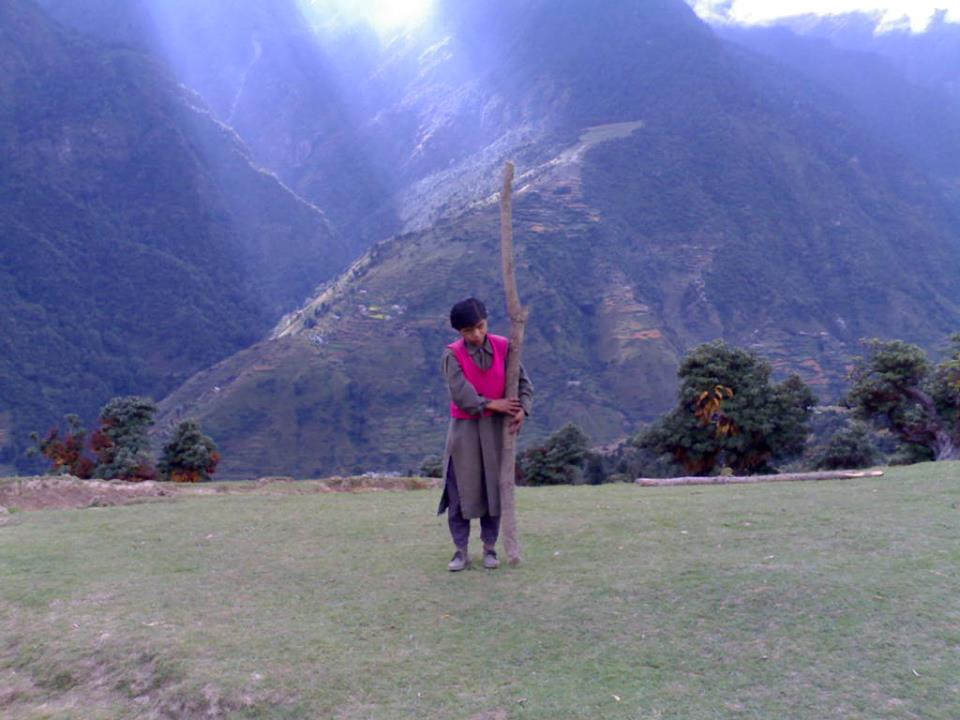
Roopkund, Roopkund Trek, Roopkund Trekking Guide, Roopkund trekking route, Roopkund trekking Guide name - Man Singh, trekking in himalayas
Roopkund, roopkund trek, trek the himalayas, roopkund lake, trekking in himalayas, travel, roopkund trek himalayas, trekking in india, roopkund trek itinerary, trek to roopkund,roopkund mystery, roopkund trekking tour, roopkund uttarakhand, roopkund trek route, trekking in himalayas in may, skeleton lake of roopkund, roopkund skeleton lake, roopkund trek package, trek the himalayas roopkund, trekking himalayas, trek india, roopkund india, roopkund skeletons, trekking, indiahikes roopkund, roopkund lake trek, skeleton lake roopkund, roopkund trek indiahikes, trekking in himachal, valley of flowers, roopkund lake mystery, roopkund trek in may, skeleton lake uttarakhand, india trekking, trekking in uttarakhand, the skeleton lake of roopkund, treks in india, roopkund lake uttarakhand, roopkund in uttarakhand, roopkund trek in october, roopkund trek cost, himalaya trekking tours, indiahikes roopkund trek, roopkund skeleton lake a himalayan mystery, full skeleton, treks in june, ronti saddle trek, lake roopkund, roopkund the mysterious skeleton lake, roopkund altitude, trekking holidays in india, bedni bugyal trek, ronti saddle, roopkund lake india, mountain trekking in india, roopkund indiahikes, yhai treks, roopkund trek in june, himalayan treks in june, uttarakhand trekking, roopkund in june
Roopkund, Roopkund Trek, Roopkund Trekking Guide, Roopkund trekking route, Roopkund trekking Guide name - Man Singh, trekking in himalayas
Roopkund, roopkund trek,trek the himalayas,roopkund lake,trekking in himalayas,travel,roopkund trek himalayas,trekking in india,roopkund trek itinerary,trek to roopkund,roopkund mystery,roopkund trekking tour,roopkund uttarakhand,roopkund trek route,trekking in himalayas in may,skeleton lake of roopkund,roopkund skeleton lake,roopkund trek package,trek the himalayas roopkund,trekking himalayas,trek india,roopkund india,roopkund skeletons,trekking,indiahikes roopkund,roopkund lake trek,skeleton lake roopkund,roopkund trek indiahikes,trekking in himachal,valley of flowers,roopkund lake mystery,roopkund trek in may,skeleton lake uttarakhand,india trekking,trekking in uttarakhand,the skeleton lake of roopkund,treks in india,roopkund lake uttarakhand,roopkund in uttarakhand,roopkund trek in october,roopkund trek cost,himalaya trekking tours,indiahikes roopkund trek,roopkund skeleton lake a himalayan mystery,full skeleton,treks in june,ronti saddle trek,lake roopkund,roopkund the mysterious skeleton lake,roopkund altitude,trekking holidays in india,bedni bugyal trek,ronti saddle,roopkund lake india,mountain trekking in india,roopkund indiahikes,yhai treks,roopkund trek in june,himalayan treks in june,uttarakhand trekking,roopkund in june